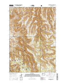
2014 Map of Lefevre Prairie
USGS Topo · Published 2014About this map
Lefevre Prairie and the surrounding high country of the Umatilla National Forest dominate this landscape where the boundaries of Gilliam, Morrow, and Wheeler counties converge. The terrain is defined by a series of deep drainages including Pullen Canyon, Big Dutch Canyon, and Little Dutch Canyon that cut through the plateaus. Settled life in this high-elevation environment is centered around the Lonerock Cem and the small network of roads like Lonerock Rd and Buttermilk Rd. Water sources are critical in this dry, dissected landscape, marked by named features such as Brandenburg Reservoir and Perry Spring. The presence of several open upland areas, such as Camas Prairie and Pool Prairie, suggests a land utilized for seasonal grazing and forest management within the protected federal lands.
Find a feature on this map
44 named features on this map. Tap any name to fly to it.
Don’t see what you’re looking for? This feature index may not catch every label — zoom into the map to look around manually.
Map Details
Editions of this 2014 Lefevre Prairie Map
This is the sole edition of this map. No revisions or reprints were ever made.
Other maps of this area

1953 · Kimberly
USGS Topo · 1:62,500

1953 · Spray
USGS Topo · 1:62,500

1953 · Pendleton
USGS Topo · 1:250,000

1955 · Canyon City
USGS Topo · 1:250,000

1956 · Pendleton
USGS Topo · 1:250,000

1959 · Canyon City
USGS Topo · 1:250,000

1969 · Lefevre Prairie
USGS Topo · 1:24,000

1969 · Buttermilk Canyon
USGS Topo · 1:24,000
1969 · Lonerock
USGS Topo · 1:24,000

1969 · Chapin Creek
USGS Topo · 1:24,000