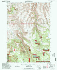
1995 Map of Lefevre Prairie
USGS Topo · Published 1998About this map
Lefevre Prairie and the surrounding high-plateau landscape of the Umatilla National Forest define this region at the intersection of Gilliam, Morrow, and Wheeler Counties. This mid-1990s data reflects a landscape shaped by intermittent water sources and the varied topography of the Blue Mountains, where Lonerock Cemetery serves as a lone marker of earlier community ties. The terrain is deeply incised by drainages such as Buttermilk Canyon and Stahl Canyon, while livestock management is evident through the presence of Brandenburg Reservoir and numerous scattered springs. High-altitude meadows like Scot Prairie and Pool Prairie are mapped alongside distinctive landmarks such as The Frog, illustrating the traditional nomenclature used by local ranchers and foresters. The survey also precisely details the First Standard Parallel South, a critical baseline for regional land division.
Find a feature on this map
30 named features on this map. Tap any name to fly to it.
Don’t see what you’re looking for? This feature index may not catch every label — zoom into the map to look around manually.
Map Details
Editions of this 1995 Lefevre Prairie Map
This is the sole edition of this map. No revisions or reprints were ever made.
Other maps of this area

1953 · Kimberly
USGS Topo · 1:62,500

1953 · Spray
USGS Topo · 1:62,500

1953 · Pendleton
USGS Topo · 1:250,000

1955 · Canyon City
USGS Topo · 1:250,000

1956 · Pendleton
USGS Topo · 1:250,000

1959 · Canyon City
USGS Topo · 1:250,000

1969 · Lefevre Prairie
USGS Topo · 1:24,000

1969 · Buttermilk Canyon
USGS Topo · 1:24,000
1969 · Lonerock
USGS Topo · 1:24,000

1969 · Chapin Creek
USGS Topo · 1:24,000