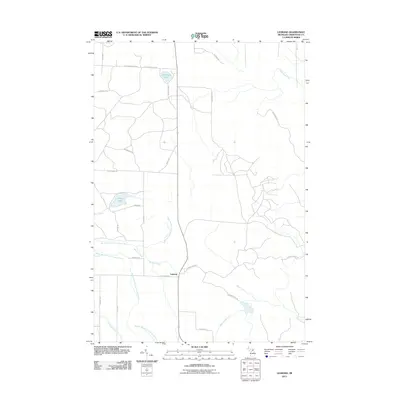
2011 Map of Legrand
USGS Topo · Published 2011About this map
Legrand sits at the center of this 2011 Cheboygan County survey, where the convergence of County Road L-6 and local routes like Ostrander RD define the local settlement pattern. The landscape is heavily influenced by the drainage of the Little Pigeon River system, specifically the North Branch Little Pigeon River and Middle Branch Little Pigeon River, which wind through the township alongside Morrow Creek and Silver Creek. Several small lakes, including Devereaux Lake and Silver Lake, anchor the residential and recreational geography of the area. This map documents a northern Michigan landscape of winding forest roads and creek basins, from Stony Creek in the southeast to Little Mud Creek in the northeast, providing a clear view of how modern property lines and roads like Merchant RD have been laid out around the region's complex hydrology.
Find a feature on this map
35 named features on this map. Tap any name to fly to it.
Don’t see what you’re looking for? This feature index may not catch every label — zoom into the map to look around manually.
Map Details
Editions of this 2011 Legrand Map
This is the sole edition of this map. No revisions or reprints were ever made.
Other maps of this area

1955 · Cheboygan
USGS Topo · 1:250,000

1957 · Tower
USGS Topo · 1:62,500

1957 · Wolverine
USGS Topo · 1:62,500

1957 · Cheboygan
USGS Topo · 1:62,500

1957 · Mullett Lake
USGS Topo · 1:62,500

1958 · Cheboygan
USGS Topo · 1:250,000

1982 · Petoskey
USGS Topo · 1:100,000

1982 · Aloha
USGS Topo · 1:25,000
1982 · Mullett Lake
USGS Topo · 1:25,000
1982 · Manning
USGS Topo · 1:25,000