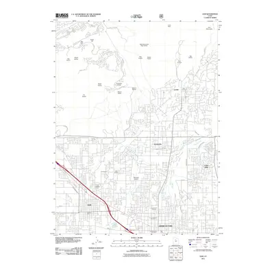
2011 Map of Lehi
USGS Topo · Published 2011About this map
Alpine, Highland, and American Fork anchor this northern Utah County landscape as it appeared in 2011, showing the dense residential expansion into the surrounding foothills. The map reveals an intricate network of historical irrigation, including the New Survey Ditch, American Fork Canyon Ditch, and McArthur Ditch, which speak to the area’s agricultural heritage. While modern subdivisions dominate the lower elevations, the northern reaches remain defined by numerous hollows like Maple Hollow and Broadleaf Hollow rising toward First Hamongog. Genealogy and local history are well-represented by several burial sites, including the Alpine Cemetery and the Pioneer Memorial Cemetery. Notable landmarks such as the Alpine Fort and Mill Pond provide specific points of reference within this rapidly developing corridor between Salt Lake City and Provo.
Find a feature on this map
52 named features on this map. Tap any name to fly to it.
Don’t see what you’re looking for? This feature index may not catch every label — zoom into the map to look around manually.
Map Details
Editions of this 2011 Lehi Map
This is the sole edition of this map. No revisions or reprints were ever made.
Other maps of this area

1885 · Salt Lake
USGS Topo · 1:250,000

1925 · Ft. Douglas
USGS Topo · 1:125,000

1928 · Ft. Douglas
USGS Topo · 1:125,000

1948 · Timpanogos Cave
USGS Topo · 1:24,000

1948 · Orem
USGS Topo · 1:24,000

1948 · Orem
USGS Topo · 1:62,500

1950 · Orem
USGS Topo · 1:24,000

1950 · Timpanogos Cave
USGS Topo · 1:24,000

1950 · Pelican Point
USGS Topo · 1:24,000
1951 · Pelican Point
USGS Topo · 1:24,000