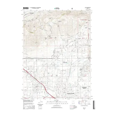
2014 Map of Lehi
USGS Topo · Published 2014About this map
Lehi and its neighboring communities in the northern Utah Valley are defined by a complex network of water management and the steep rise of the Wasatch Range. The landscape transitions from the residential developments of Highland and Cedar Hills to the foothills of the Traverse Mountains. Significant local history is preserved at the Alpine Fort and through numerous burial grounds like the Pioneer Memorial Cem and Lehi Cem. To the north, the terrain becomes increasingly vertical as it enters the Uinta National Forest, marked by distinctive features such as First Hamongog and Schoolhouse Springs. The Union Pacific rail line and the Mill Pond highlight the industrial and natural infrastructure supporting this rapidly growing corridor between Draper and American Fork.
Find a feature on this map
162 named features on this map. Tap any name to fly to it.
Don’t see what you’re looking for? This feature index may not catch every label — zoom into the map to look around manually.
Map Details
Editions of this 2014 Lehi Map
This is the sole edition of this map. No revisions or reprints were ever made.
Other maps of this area

1885 · Salt Lake
USGS Topo · 1:250,000

1925 · Ft. Douglas
USGS Topo · 1:125,000

1928 · Ft. Douglas
USGS Topo · 1:125,000

1948 · Timpanogos Cave
USGS Topo · 1:24,000

1948 · Orem
USGS Topo · 1:24,000

1948 · Orem
USGS Topo · 1:62,500

1950 · Orem
USGS Topo · 1:24,000

1950 · Timpanogos Cave
USGS Topo · 1:24,000

1950 · Pelican Point
USGS Topo · 1:24,000
1951 · Pelican Point
USGS Topo · 1:24,000