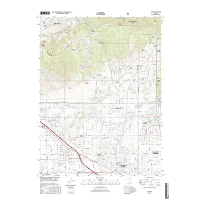
2017 Map of Lehi
USGS Topo · Published 2017About this map
Utah Valley's northern expansion is recorded here as the residential grids of Lehi, American Fork, and Alpine extend toward the Traverse Mountains. The landscape is defined by a sophisticated 19th and 20th-century irrigation network, essential for the region's agricultural roots, featuring the Murdock Canal, American Fork-Canyon Ditch, and Bull River Ditch. These waterways, alongside smaller diversions like Fox Ditch and Cedar Hollow Ditch, reveal how water management shaped the local geography before suburban development fully took hold. The Union Pacific Railroad cuts through the valley floor, passing Mill Pond and the Lehi City Cem, anchoring the historic transportation and settlement corridor. To the north and east, the terrain rises sharply into the Wasatch Range and the Uinta National Forest, where steep canyons such as Dry Creek Canyon and Box Elder Canyon provide a stark contrast to the dense municipal planning below.
Find a feature on this map
180 named features on this map. Tap any name to fly to it.
Don’t see what you’re looking for? This feature index may not catch every label — zoom into the map to look around manually.
Map Details
Editions of this 2017 Lehi Map
This is the sole edition of this map. No revisions or reprints were ever made.
Other maps of this area

1885 · Salt Lake
USGS Topo · 1:250,000

1925 · Ft. Douglas
USGS Topo · 1:125,000

1928 · Ft. Douglas
USGS Topo · 1:125,000

1948 · Timpanogos Cave
USGS Topo · 1:24,000

1948 · Orem
USGS Topo · 1:24,000

1948 · Orem
USGS Topo · 1:62,500

1950 · Orem
USGS Topo · 1:24,000

1950 · Timpanogos Cave
USGS Topo · 1:24,000

1950 · Pelican Point
USGS Topo · 1:24,000
1951 · Pelican Point
USGS Topo · 1:24,000