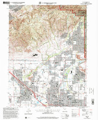
1998 Map of Lehi
USGS Topo · Published 2000About this map
The Traverse Mountains stand watch over the northern Utah Valley, where the rapid late-century expansion of residential boundaries meets the steep slopes of the Lone Peak Wilderness. This map captures a significant period of suburban growth as the corporate limits of Lehi, American Fork, and Highland push northward into formerly agricultural foothills. The landscape is defined by an intricate network of water management, including the Jordan Canal and Murdock Canal, which supported the area's transition from orchards and fields to modern neighborhoods. Local heritage is preserved in landmarks such as Daughters of the Pioneers Park and the large American Fork Cemetery, while the northern reaches show the early encroachment of development into Corner Canyon and Hog Hollow. Facilities like the Utah State Developmental Center and numerous community schools point to the established institutional roots of these growing Wasatch Front communities.
Find a feature on this map
114 named features on this map. Tap any name to fly to it.
Don’t see what you’re looking for? This feature index may not catch every label — zoom into the map to look around manually.
Map Details
Editions of this 1998 Lehi Map
This is the sole edition of this map. No revisions or reprints were ever made.
Other maps of this area

1885 · Salt Lake
USGS Topo · 1:250,000

1925 · Ft. Douglas
USGS Topo · 1:125,000

1928 · Ft. Douglas
USGS Topo · 1:125,000

1948 · Timpanogos Cave
USGS Topo · 1:24,000

1948 · Orem
USGS Topo · 1:24,000

1948 · Orem
USGS Topo · 1:62,500

1950 · Orem
USGS Topo · 1:24,000

1950 · Timpanogos Cave
USGS Topo · 1:24,000

1950 · Pelican Point
USGS Topo · 1:24,000
1951 · Pelican Point
USGS Topo · 1:24,000