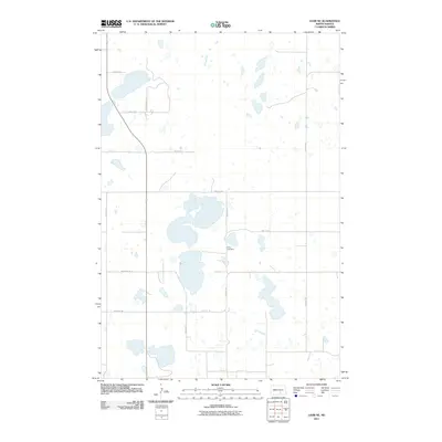
2011 Map of Lehr NE
USGS Topo · Published 2011About this map
King Cemetery serves as a central landmark in this rural Logan County landscape, where the prairie is defined by a dense network of small wetlands and glacial potholes. The region is strictly organized by a section-line grid of local routes such as 64th St SE, 68th St SE, and 53rd Ave SE. These roads navigate around dozens of unnamed water bodies that characterize the drainage patterns of the Missouri Coteau. Near the southern edge of the quadrangle, Bainstad Rd and 70th St SE cut across the low-lying terrain. The map depicts a late twentieth-century agricultural landscape where the placement of the cemetery and the precise intersection of roads like Mcintosh St N indicate established rural community hubs in a sparsely populated portion of the state.
Find a feature on this map
14 named features on this map. Tap any name to fly to it.
Don’t see what you’re looking for? This feature index may not catch every label — zoom into the map to look around manually.
Map Details
Editions of this 2011 Lehr NE Map
This is the sole edition of this map. No revisions or reprints were ever made.
Other maps of this area

1953 · Jamestown
USGS Topo · 1:250,000

1956 · Jamestown
USGS Topo · 1:250,000

1982 · Fredonia NW
USGS Topo · 1:24,000

1982 · Guyson
USGS Topo · 1:24,000

1982 · Lehr NW
USGS Topo · 1:24,000

1982 · Lehr NE
USGS Topo · 1:24,000

1982 · Lehr SW
USGS Topo · 1:24,000
1982 · Lehr
USGS Topo · 1:24,000

1983 · Streeter SW
USGS Topo · 1:24,000

1983 · Streeter SE
USGS Topo · 1:24,000