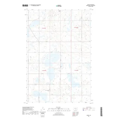
2017 Map of Lehr NE
USGS Topo · Published 2017About this map
Glacial geology and rural persistence define this corner of Logan County, dominated by the undulating topography of the Streeter Moraine. This 2017 survey reveals a landscape sparsely populated but deeply rooted in its local heritage, with the grid of section lines and gravel roads such as Mcintosh St N and 53rd Ave SE providing the primary structure for the region. The map serves as a vital record for family historians, anchoring the community's past at the Evangelical Lutheran Zion Cem and King Lutheran Cem. These sites, set against a backdrop of numerous small prairie potholes and wetlands, illustrate the enduring presence of early 20th-century Lutheran settlement patterns in the North Dakota prairie well into the 21st century.
Find a feature on this map
21 named features on this map. Tap any name to fly to it.
Don’t see what you’re looking for? This feature index may not catch every label — zoom into the map to look around manually.
Map Details
Editions of this 2017 Lehr NE Map
This is the sole edition of this map. No revisions or reprints were ever made.
Other maps of this area

1953 · Jamestown
USGS Topo · 1:250,000

1956 · Jamestown
USGS Topo · 1:250,000

1982 · Fredonia NW
USGS Topo · 1:24,000

1982 · Guyson
USGS Topo · 1:24,000

1982 · Lehr NW
USGS Topo · 1:24,000

1982 · Lehr NE
USGS Topo · 1:24,000

1982 · Lehr SW
USGS Topo · 1:24,000
1982 · Lehr
USGS Topo · 1:24,000

1983 · Streeter SW
USGS Topo · 1:24,000

1983 · Streeter SE
USGS Topo · 1:24,000