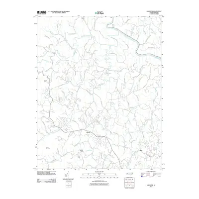
2010 Map of Leicester
USGS Topo · Published 2010About this map
Leicester serves as the central hub for this rural Buncombe County landscape, where the drainage of Newfound Creek and South Turkey Creek shapes the local geography. The map reveals a high density of family-named roads and landmarks, reflecting deep-rooted settlement patterns in areas like Patton Cove and Worley Cove. The northeastern corner is defined by the winding course of the French Broad River at Bailey Bend, a significant waterway that has long influenced transportation and agriculture in the region.
Find a feature on this map
88 named features on this map. Tap any name to fly to it.
Don’t see what you’re looking for? This feature index may not catch every label — zoom into the map to look around manually.
Map Details
Editions of this 2010 Leicester Map
This is the sole edition of this map. No revisions or reprints were ever made.
Other maps of this area

1894 · Asheville
USGS Topo · 1:125,000

1901 · Asheville
USGS Topo · 1:125,000

1935 · Canton
USGS Topo · 1:24,000

1935 · Spring Creek
USGS Topo · 1:24,000

1936 · Marshall
USGS Topo · 1:24,000

1936 · Sandymush
USGS Topo · 1:24,000

1936 · Enka
USGS Topo · 1:24,000

1936 · Weaverville
USGS Topo · 1:24,000

1936 · Mars Hill
USGS Topo · 1:24,000
1936 · Leicester
USGS Topo · 1:24,000