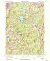
1969 Map of Leicester
USGS Topo · Published 1971About this map
The hills of Worcester County are defined by a network of industrial waterpower and transportation corridors in this late 1960s survey. Industrial history is etched into the landscape along the Penn Central railroad line, which connects settlements like Charlton Depot and Rochdale while skirting the Mass Turnpike. The central portion of the map is dominated by large water bodies, including Stiles Reservoir and Cedar Meadow Pond, which supported the mills of the region's textile era. Local history is preserved in small burial grounds such as Pine Grove Cem and Northside Cem. The map also captures the development of education and recreation in the area, showing the Junior College in Leicester and expansive wooded tracts like Spencer State Forest. To the south, the Buffumville Reservoir and French River signify modern water management and conservation efforts in the valley.
Find a feature on this map
83 named features on this map. Tap any name to fly to it.
Don’t see what you’re looking for? This feature index may not catch every label — zoom into the map to look around manually.
Map Details
Editions of this 1969 Leicester Map
3 editions found
Other maps of this area

1885 · Worcester
USGS Topo · 1:62,500

1886 · Worcester
USGS Topo · 1:62,500

1887 · Brookfield
USGS Topo · 1:62,500

1887 · Barre
USGS Topo · 1:62,500

1889 · Webster
USGS Topo · 1:62,500

1889 · Barre
USGS Topo · 1:62,500

1890 · Brookfield
USGS Topo · 1:62,500

1892 · Webster
USGS Topo · 1:62,500

1892 · Worcester
USGS Topo · 1:62,500

1893 · Brookfield
USGS Topo · 1:62,500