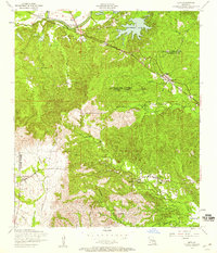
1954 Map of Lena
USGS Topo · Published 1959This historical map portrays the area of Lena in 1954, primarily covering Rapides Parish as well as portions of Natchitoches Parish. Featuring a scale of 1:24000, this map provides a highly detailed snapshot of the terrain, roads, buildings, counties, and historical landmarks in the Lena region at the time. Published in 1959, it is one of 3 known editions of this map due to revisions or reprints.
Find a feature on this map
40 named features on this map. Tap any name to fly to it.
Don’t see what you’re looking for? This feature index may not catch every label — zoom into the map to look around manually.
Map Details
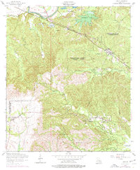
Editions of this 1954 Lena Map
3 editions found
Historical Maps of Campbell Through Time
42 maps found

1932 Boyce SW
Rapides Parish, LA

1935 Pawnee
Rapides Parish, LA

1937 Chopin NE
Rapides Parish, LA

1937 Chopin SE
Rapides Parish, LA

1944 Chopin
Rapides Parish, LA

1945 Boyce SE
Rapides Parish, LA

1948 Chopin
Rapides Parish, LA

1949 Boyce NW
Rapides Parish, LA

1949 Boyce SE
Rapides Parish, LA

1954 Chopin
Rapides Parish, LA

1954 Jericho
Rapides Parish, LA

1954 Leander SE
Rapides Parish, LA

1954 Lena
Rapides Parish, LA

1954 Pawnee
Rapides Parish, LA

1954 Sieper
Rapides Parish, LA

1968 Pawnee
Rapides Parish, LA

1971 Elmer
Rapides Parish, LA

1971 Gardner
Rapides Parish, LA

1971 Melder
Rapides Parish, LA

1971 Woodworth West
Rapides Parish, LA

1972 Buckeye
Rapides Parish, LA

1972 Green Gables
Rapides Parish, LA

1972 Holloway
Rapides Parish, LA

1972 Latanier
Rapides Parish, LA

1972 Libuse
Rapides Parish, LA

1972 Rapides
Rapides Parish, LA

1972 Woodworth East
Rapides Parish, LA

1978 Sieper
Rapides Parish, LA

1994 Buckeye
Rapides Parish, LA

1994 Holloway
Rapides Parish, LA

1998 Holloway
Rapides Parish, LA

2003 Afeman
Rapides Parish, LA

2003 Elmer
Rapides Parish, LA

2003 Gardner
Rapides Parish, LA

2003 Green Gables
Rapides Parish, LA

2003 Jericho
Rapides Parish, LA

2003 Melder
Rapides Parish, LA

2003 Pawnee
Rapides Parish, LA

2003 Rapides
Rapides Parish, LA

2003 Sieper
Rapides Parish, LA

2003 Woodworth East
Rapides Parish, LA

2003 Woodworth West
Rapides Parish, LA