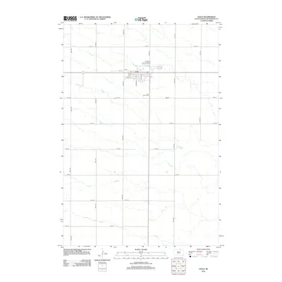
2012 Map of Leola
USGS Topo · Published 2012About this map
Leola serves as the focal point for this section of McPherson County, organized around a traditional grid with central arteries like Broadway and Leola Ave. The town is surrounded by a sprawling landscape of section-line roads, such as 361st Ave and 114th St, that define the local agricultural layout. Water drainage is channeled through Foot Creek, which meanders past the northern edge of the settlement near Our Lady of Perpetual Help Cemetery. To the south, Green Mound Cemetery sits along the route of the north-south thoroughfare, anchoring the community's local history. This 2012 survey illustrates a classic Great Plains settlement pattern where the town center remains closely integrated with the surrounding prairie and its watercourses.
Find a feature on this map
24 named features on this map. Tap any name to fly to it.
Don’t see what you’re looking for? This feature index may not catch every label — zoom into the map to look around manually.
Map Details
Editions of this 2012 Leola Map
This is the sole edition of this map. No revisions or reprints were ever made.
Other maps of this area

1899 · Ellendale
USGS Topo · 1:125,000

1954 · Aberdeen
USGS Topo · 1:250,000

1956 · Aberdeen
USGS Topo · 1:250,000

1968 · Long Lake SE
USGS Topo · 1:24,000

1968 · Forbes SE
USGS Topo · 1:24,000

1968 · Forbes SW
USGS Topo · 1:24,000

1970 · Wetonka South
USGS Topo · 1:24,000

1970 · Leola
USGS Topo · 1:24,000
1970 · Wetonka North
USGS Topo · 1:24,000

1970 · Leola SW
USGS Topo · 1:24,000