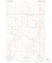
1970 Map of Wetonka North
USGS Topo · Published 1973About this map
Wetonka sits at the southern edge of this prairie landscape, serving as a focal point for the surrounding rural townships of Willow, Washington, and Lincoln. The terrain is defined by a slow, meandering drainage system where Willow Creek and Foot Creek wind through the glaciated plains of McPherson County. An extensive Old Railroad Grade cuts a diagonal path across the sections, marking the historical corridor of the Minneapolis and St. Louis Railway that once linked these small agricultural communities. In the southwest corner, Crompton Lake provides one of the few significant standing water bodies in an area otherwise characterized by intermittent ponds and wetlands. The map illustrates the strictly organized section lines and rural road network that supported the local farming economy in the late 1960s and early 1970s.
Find a feature on this map
8 named features on this map. Tap any name to fly to it.
Don’t see what you’re looking for? This feature index may not catch every label — zoom into the map to look around manually.
Map Details
Editions of this 1970 Wetonka North Map
This is the sole edition of this map. No revisions or reprints were ever made.
Other maps of this area

1894 · Ellendale
USGS Topo · 1:62,500

1899 · Ellendale
USGS Topo · 1:125,000

1954 · Aberdeen
USGS Topo · 1:250,000

1956 · Aberdeen
USGS Topo · 1:250,000

1968 · Forbes SE
USGS Topo · 1:24,000

1968 · Forbes SW
USGS Topo · 1:24,000
1968 · Frederick SW
USGS Topo · 1:24,000

1970 · Wetonka South
USGS Topo · 1:24,000

1970 · Leola
USGS Topo · 1:24,000
1970 · Richmond SW
USGS Topo · 1:24,000