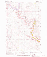
1968 Map of Frederick SW
USGS Topo · Published 1970About this map
Elm Lake and the meandering Elm River define the terrain of this north-central South Dakota landscape during the late 1960s. The map captures a largely agricultural region organized into named districts such as Wachter, Palmyra, and Carl. The river's winding course is the primary geological feature, controlled in part by the Spillway Elev 1458 at the lake's southern edge. Settlement patterns are sparse, represented by isolated structures and a centrally located Townhall within Palmyra. Evidence of local industry is limited to a single Gravel Pit near the river's bend. This survey is particularly notable for its inclusion of fine red dashed lines that indicate specific fence and field lines visible from 1965 aerial photography, offering genealogists and land historians a precise view of mid-century property boundaries across Allison, Willow, and Franklyn.
Find a feature on this map
12 named features on this map. Tap any name to fly to it.
Don’t see what you’re looking for? This feature index may not catch every label — zoom into the map to look around manually.
Map Details
Editions of this 1968 Frederick SW Map
This is the sole edition of this map. No revisions or reprints were ever made.
Other maps of this area

1894 · Ellendale
USGS Topo · 1:62,500

1899 · Ellendale
USGS Topo · 1:125,000

1952 · Richmond NE
USGS Topo · 1:24,000

1953 · Frederick
USGS Topo · 1:24,000

1953 · Ellendale South
USGS Topo · 1:24,000

1954 · Aberdeen
USGS Topo · 1:250,000

1956 · Aberdeen
USGS Topo · 1:250,000
1968 · Frederick NW
USGS Topo · 1:24,000

1968 · Forbes
USGS Topo · 1:24,000

1968 · Forbes SE
USGS Topo · 1:24,000