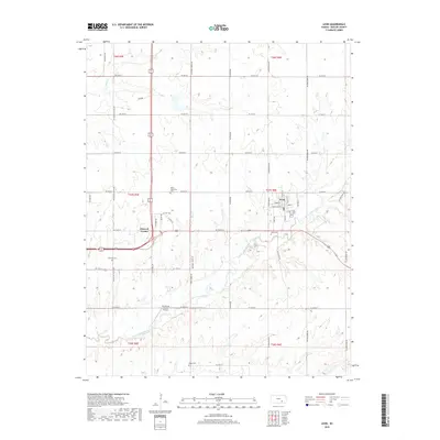
2018 Map of Leon
USGS Topo · Published 2018About this map
The Little Walnut River meanders across this Butler County landscape, carving a valley that separates the township of Leon from the surrounding high ground. This 2018 survey captures the town's grid established along North St and S Mill Rd, providing a clear view of the community's layout and its relationship to the river's bend. Genealogists will find a concentration of burial sites throughout the township, including the Leon Cem just south of town, and more remote locations like Butts-Wakefield Cem, Garrison Cem, and Bogle Cem. Beyond the residential center, the map identifies small rural landmarks such as Pickrell Corner and the private Riverbend Ranch Airport, illustrating how aviation and historical crossroads remain integrated into this agricultural corridor east of the Flint Hills.
Find a feature on this map
53 named features on this map. Tap any name to fly to it.
Don’t see what you’re looking for? This feature index may not catch every label — zoom into the map to look around manually.
Map Details
Editions of this 2018 Leon Map
This is the sole edition of this map. No revisions or reprints were ever made.
Other maps of this area

1888 · Eldorado
USGS Topo · 1:125,000

1955 · Wichita
USGS Topo · 1:250,000

1958 · Wichita
USGS Topo · 1:250,000

1961 · Augusta
USGS Topo · 1:24,000

1961 · Pontiac
USGS Topo · 1:24,000

1961 · El Dorado
USGS Topo · 1:24,000

1961 · Gordon
USGS Topo · 1:24,000
1961 · El Dorado SW
USGS Topo · 1:24,000

1963 · Leon
USGS Topo · 1:24,000

1964 · Augusta SE
USGS Topo · 1:24,000