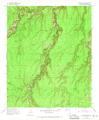
1965 Map of Leonard Canyon
USGS Topo · Published 1967About this map
Leonard Canyon carves a deep, winding path through the high timberlands of northern Arizona, serving as the border between the Coconino National Forest and the Sitgreaves National Forest. This mid-1960s survey captures a landscape defined by seasonal water management and early ranching access, featuring numerous stock tanks like Morgan Tank and Victorine Tank scattered across the limestone plateaus. The placement of Macks Crossing and Victorine Crossing highlights the historical importance of established fords for traversing the canyon's steep walls. On the eastern edge, isolated outposts such as Wiggins Ranch and Hugh Barr Ranch mark the limited human footprint in this canyon-dissected terrain. These features, along with a network of traditional routes like the Soldier Trail and Pack Trail, provide a look at how this remote backcountry was navigated and utilized before modern infrastructure expansion.
Find a feature on this map
37 named features on this map. Tap any name to fly to it.
Don’t see what you’re looking for? This feature index may not catch every label — zoom into the map to look around manually.
Map Details
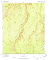
Editions of this 1965 Leonard Canyon Map
2 editions found
Other maps of this area

1886 · Holbrook
USGS Topo · 1:250,000

1887 · Verde
USGS Topo · 1:250,000

1892 · Verde
USGS Topo · 1:250,000

1893 · Holbrook
USGS Topo · 1:250,000

1934 · Promontory Butte
USGS Topo · 1:62,500

1939 · Promontory Butte
USGS Topo · 1:62,500

1952 · Promontory Butte
USGS Topo · 1:62,500

1954 · Holbrook
USGS Topo · 1:250,000

1957 · Holbrook
USGS Topo · 1:250,000

1958 · Holbrook
USGS Topo · 1:250,000