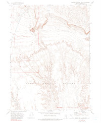
1972 Map of Leonard Cr. Slough North
USGS Topo · Published 1990About this map
Black Rock Desert dominates the southern reaches of this 1970s landscape, where the arid basin floor meets the drainage systems of northern Humboldt County. The geography is defined by the seasonal flow of Leonard Creek and the intricate channels of Leonard Creek Slough, which trace the low-lying terrain. Human activity in this desert environment is marked by essential water management and resource extraction, including Montero Reservoir, scattered wells, and Gravel Pits. Higher elevations to the north provide a stark contrast to the flats, with Windy Point overlooking the vast expanse. This map reveals a landscape where life and movement are dictated by water sources like Bartlett Creek and various unnamed springs, illustrating the remote and specialized nature of high-desert ranching and travel in Nevada.
Find a feature on this map
14 named features on this map. Tap any name to fly to it.
Don’t see what you’re looking for? This feature index may not catch every label — zoom into the map to look around manually.
Map Details
Editions of this 1972 Leonard Cr. Slough North Map
2 editions found

Other maps of this area

1886 · Disaster
USGS Topo · 1:250,000

1893 · Disaster
USGS Topo · 1:250,000

1954 · Vya
USGS Topo · 1:250,000

1958 · Vya
USGS Topo · 1:250,000

1962 · Vya
USGS Topo · 1:250,000

1965 · Idaho Canyon
USGS Topo · 1:62,500

1965 · Duffer Peak
USGS Topo · 1:62,500

1972 · Deer Creek Slough
USGS Topo · 1:24,000

1972 · Pinto Mountain
USGS Topo · 1:24,000

1972 · Hobo Canyon
USGS Topo · 1:24,000