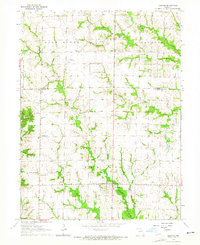
1963 Map of Leonard
USGS Topo · Published 1965About this map
The agrarian landscape of Taylor township in Shelby County comes into focus in this early 1960s survey, defined by the winding course of Black Creek and the Salt River. The small settlement of Leonard serves as a local hub, while the community of Cherry Box appears further north along the Knox and Shelby County line. This map is particularly dense with genealogical sites, showing numerous family and community burial grounds such as Antioch Cem, Garnett Cem, and Cockram Cem. The Church of the Brethren stands as a spiritual landmark in the western section of the township. In a nod to the era's local aviation, the private Rogers Landing Strip is clearly marked amidst the sectioned farm fields. Tributaries like Lost Branch and Potter Branch carve through the terrain, illustrating the drainage patterns that shaped the placement of early homesteads and roads.
Find a feature on this map
22 named features on this map. Tap any name to fly to it.
Don’t see what you’re looking for? This feature index may not catch every label — zoom into the map to look around manually.
Map Details
Editions of this 1963 Leonard Map
This is the sole edition of this map. No revisions or reprints were ever made.
Other maps of this area

1903 · Edina
USGS Topo · 1:125,000

1908 · Atlanta
USGS Topo · 1:62,500

1953 · Moberly
USGS Topo · 1:250,000

1954 · Centerville
USGS Topo · 1:250,000

1954 · Moberly
USGS Topo · 1:250,000

1957 · Moberly
USGS Topo · 1:250,000

1957 · Centerville
USGS Topo · 1:250,000

1958 · Centerville
USGS Topo · 1:250,000

1960 · Moberly
USGS Topo · 1:250,000
1964 · Hagers Grove
USGS Topo · 1:24,000