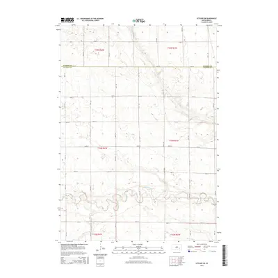
2015 Map of Letcher SW
USGS Topo · Published 2015About this map
Firesteel Creek meanders through the southern portion of this landscape, marking a significant drainage corridor across the rural plains. The area is characterized by the intersection of Sanborn and Davison counties, where a precise grid of section lines and range boundaries, such as t104n r62w and t104n r61w, defines the agricultural layout. Smaller waterways like Dry Run intersect this grid, illustrating the natural drainage patterns that local farmers navigated when establishing their homesteads. The surveyor's work reflects a highly organized land management system, where roads like 243rd St and 400th Ave serve as the primary conduits between scattered farmsteads and rural holdings. This documentation of the South Dakota prairie emphasizes the relationship between the persistent natural features of the creek beds and the rigid human-imposed geometry of the Public Land Survey System.
Find a feature on this map
24 named features on this map. Tap any name to fly to it.
Don’t see what you’re looking for? This feature index may not catch every label — zoom into the map to look around manually.
Map Details
Editions of this 2015 Letcher SW Map
This is the sole edition of this map. No revisions or reprints were ever made.
Other maps of this area

1899 · Mitchell
USGS Topo · 1:125,000

1955 · Mitchell
USGS Topo · 1:250,000

1957 · Loomis
USGS Topo · 1:24,000

1957 · Letcher NE
USGS Topo · 1:24,000

1957 · Mitchell
USGS Topo · 1:24,000

1959 · Mitchell
USGS Topo · 1:250,000
1979 · Letcher
USGS Topo · 1:24,000
1979 · Letcher SW
USGS Topo · 1:24,000

1979 · Storla
USGS Topo · 1:24,000
1979 · Twin Lakes
USGS Topo · 1:24,000