
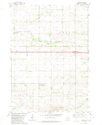
1979 Map of Storla
USGS Topo · Published 1980About this map
The unincorporated community of Storla serves as the focal point for this agrarian landscape in the late 1970s. Situated at the crossroads of Aurora, Sanborn, and Davison counties, the area is defined by the winding course of Firesteel Creek and its West Branch. The rural social fabric is clearly visible through a network of established institutions including Trinity Ch, Victor Ch, and Immanuel Ch, alongside the Blendon Sch. This survey illustrates a prairie economy centered on township divisions like Belford and Elliott, where small-scale extraction is noted at various Gravel Pits. Local genealogy is anchored by landmarks such as the Knutson Cem, which together with the scattered churches, points to the enduring settlement patterns of the South Dakota plains during this era.
Find a feature on this map
19 named features on this map. Tap any name to fly to it.
Don’t see what you’re looking for? This feature index may not catch every label — zoom into the map to look around manually.
Map Details
Editions of this 1979 Storla Map
This is the sole edition of this map. No revisions or reprints were ever made.
Other maps of this area

1899 · Mitchell
USGS Topo · 1:125,000

1955 · Mitchell
USGS Topo · 1:250,000

1959 · Mitchell
USGS Topo · 1:250,000
1979 · Fraser Dam
USGS Topo · 1:24,000
1979 · Letcher
USGS Topo · 1:24,000
1979 · Letcher SW
USGS Topo · 1:24,000

1979 · Storla SW
USGS Topo · 1:24,000
1979 · Twin Lakes
USGS Topo · 1:24,000

1980 · Mount Vernon
USGS Topo · 1:24,000
1980 · Betts
USGS Topo · 1:24,000