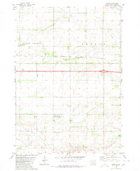
1980 Map of Betts
USGS Topo · Published 1980About this map
Dry Run and Enemy Creek carve through the agricultural landscape of Davison County, defining the drainage patterns of this South Dakota prairie. The Chicago Milwaukee St Paul and Pacific railroad bisects the region, serving as a critical corridor for the transport of goods between rural outposts like Betts. The map reveals a highly organized land system divided into townships such as Mount Vernon, Beulah, Union, and Lisbon.
Find a feature on this map
10 named features on this map. Tap any name to fly to it.
Don’t see what you’re looking for? This feature index may not catch every label — zoom into the map to look around manually.
Map Details
Editions of this 1980 Betts Map
This is the sole edition of this map. No revisions or reprints were ever made.
Other maps of this area

1899 · Mitchell
USGS Topo · 1:125,000

1955 · Mitchell
USGS Topo · 1:250,000

1957 · Loomis
USGS Topo · 1:24,000

1957 · Mitchell
USGS Topo · 1:24,000

1959 · Mitchell
USGS Topo · 1:250,000
1979 · Letcher SW
USGS Topo · 1:24,000

1979 · Storla
USGS Topo · 1:24,000

1980 · Old Stickney Lake
USGS Topo · 1:24,000
1980 · Mitchell SW
USGS Topo · 1:24,000
1980 · Shoemaker Dam
USGS Topo · 1:24,000