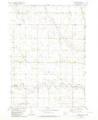
1979 Map of Letcher SW
USGS Topo · Published 1980About this map
Firesteel Creek meanders across the southern landscape of this prairie region on the border of Sanborn and Davison Counties. This late 1970s survey captures a rural environment defined by vast agricultural sections and the presence of artesian water sources, including several Flowing Wells and a specifically noted Flowing Well. The rail infrastructure of the Chicago Milwaukee St Paul and Pacific railroad cuts through the northeastern corner, providing a vital link for the agricultural townships of Elliott, Letcher, and Badger.
Find a feature on this map
15 named features on this map. Tap any name to fly to it.
Don’t see what you’re looking for? This feature index may not catch every label — zoom into the map to look around manually.
Map Details
Editions of this 1979 Letcher SW Map
This is the sole edition of this map. No revisions or reprints were ever made.
Other maps of this area

1899 · Mitchell
USGS Topo · 1:125,000

1955 · Mitchell
USGS Topo · 1:250,000

1957 · Loomis
USGS Topo · 1:24,000

1957 · Letcher NE
USGS Topo · 1:24,000

1957 · Mitchell
USGS Topo · 1:24,000

1959 · Mitchell
USGS Topo · 1:250,000
1979 · Letcher
USGS Topo · 1:24,000

1979 · Storla
USGS Topo · 1:24,000
1979 · Twin Lakes
USGS Topo · 1:24,000

1980 · Mount Vernon
USGS Topo · 1:24,000
Featured Places
- Elliott Township, SD
- Beulah Township, SD
- Mount Vernon Township, SD
- Badger Township, SD
- Blendon Township, SD