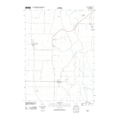
2010 Map of Letts
USGS Topo · Published 2010About this map
Letts and Grandview serve as the primary residential hubs in this section of Muscatine County, where the landscape is defined by the complex hydrology of the Mississippi River floodplain. The low-lying eastern terrain is marked by Muscatine Slough, which winds past Klum Lake and Keokuk Lake, indicating a landscape shaped by historical river movements. These wet lowlands contrast with the higher agricultural ground to the west, where family legacies are preserved in numerous small burial grounds including Kiser Cemetery, Brockway Cemetery, and Thompson Cemetery. The area's infrastructure is supported by the Muscatine Municipal Airport in the northeast and a network of county roads like Co HWY g38 that connect these rural communities. Local commerce and recreation are visible through features such as the Warehouse Raceway near Fruitland.
Find a feature on this map
45 named features on this map. Tap any name to fly to it.
Don’t see what you’re looking for? This feature index may not catch every label — zoom into the map to look around manually.
Map Details
Editions of this 2010 Letts Map
This is the sole edition of this map. No revisions or reprints were ever made.
Other maps of this area

1946 · Wapello
USGS Topo · 1:62,500

1948 · Muscatine
USGS Topo · 1:62,500

1949 · Wapello
USGS Topo · 1:62,500

1953 · Toolesboro
USGS Topo · 1:24,000

1953 · Blanchard Island
USGS Topo · 1:24,000
1953 · Muscatine
USGS Topo · 1:24,000

1958 · Davenport
USGS Topo · 1:250,000

1961 · Davenport
USGS Topo · 1:250,000

1962 · Davenport
USGS Topo · 1:250,000

1965 · Letts
USGS Topo · 1:24,000