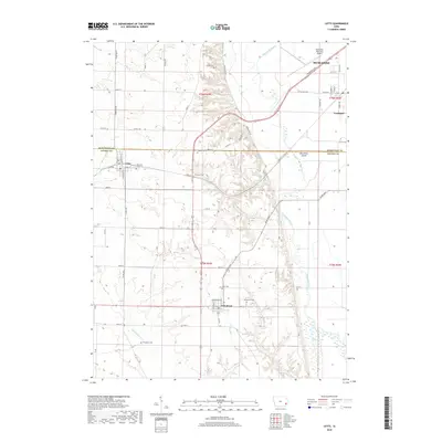
2018 Map of Letts
USGS Topo · Published 2018About this map
Muscatine Island and the fertile lowlands of the Muscatine Slough define the eastern portion of this landscape, where the Muscatine County and Louisa County line intersects the agricultural heartland. The interior is marked by a network of drainage ways including Indian Creek, Whisky Run, and Michaelis Creek, which carve through the terrain between the upland settlements of Letts and Grandview. Genealogists will find a high density of small family and community burial grounds throughout the countryside, such as Lettsville Cemetery, Brockway Cemetery, and Thompson Cemetery. The map also details the southern expansion of Muscatine and the Muscatine Municipal Airport near Fruitland, illustrating the transition from industrial city outskirts to the quiet wetland edges of Klum Lake.
Find a feature on this map
66 named features on this map. Tap any name to fly to it.
Don’t see what you’re looking for? This feature index may not catch every label — zoom into the map to look around manually.
Map Details
Editions of this 2018 Letts Map
This is the sole edition of this map. No revisions or reprints were ever made.
Other maps of this area

1946 · Wapello
USGS Topo · 1:62,500

1948 · Muscatine
USGS Topo · 1:62,500

1949 · Wapello
USGS Topo · 1:62,500

1953 · Toolesboro
USGS Topo · 1:24,000

1953 · Blanchard Island
USGS Topo · 1:24,000
1953 · Muscatine
USGS Topo · 1:24,000

1958 · Davenport
USGS Topo · 1:250,000

1961 · Davenport
USGS Topo · 1:250,000

1962 · Davenport
USGS Topo · 1:250,000

1965 · Letts
USGS Topo · 1:24,000