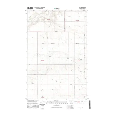
2017 Map of Letz Lake
USGS Topo · Published 2017About this map
Letz Lake sits at the center of this 2017 survey, surrounded by the distinctive drainage patterns of north-central Montana. The landscape is characterized by numerous dry coulees, including Pondera Coulee and Wilcox Coulee, which weave through the agricultural sections of Pondera County. To the northwest, the Dry Fork Marias River cuts across the corner of the map, while long, straight section-line roads like Sollid Rd and Furlough Rd define the local transportation network.
Find a feature on this map
34 named features on this map. Tap any name to fly to it.
Don’t see what you’re looking for? This feature index may not catch every label — zoom into the map to look around manually.
Map Details
Editions of this 2017 Letz Lake Map
This is the sole edition of this map. No revisions or reprints were ever made.
Other maps of this area

1920 · Conrad
USGS Topo · 1:125,000

1954 · Shelby
USGS Topo · 1:250,000

1958 · Shelby
USGS Topo · 1:250,000
1967 · Conrad
USGS Topo · 1:24,000

1967 · Conrad Butte
USGS Topo · 1:24,000

1967 · Brady
USGS Topo · 1:24,000

1967 · Fowler Coulee SW
USGS Topo · 1:24,000
1967 · Pioneer School
USGS Topo · 1:24,000

1967 · Fowler Coulee NW
USGS Topo · 1:24,000
1967 · Conrad SW
USGS Topo · 1:24,000