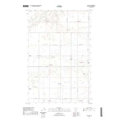
2020 Map of Letz Lake
USGS Topo · Published 2020About this map
Dry Fork Marias River meanders across the northwest corner of this Pondera County landscape, a region defined by its intricate network of coulees and rural section roads. The eponymous Letz Lake sits near the northern boundary, while the surrounding plains are carved by drainages including Favot Coulee, Power Coulee, and Pondera Coulee. This high plains environment is etched with the history of rural education, evidenced by the location of the Dusell School near the river fork. A dense grid of local arteries such as Sollid Rd, Liberty School Rd, and Kelly Rd facilitates movement between these scattered geographical features. The map illustrates a classic Montana agricultural layout where natural erosion patterns like Wilcox Coulee and Berens Coulee intersect with the rigid geometry of the Public Land Survey System.
Find a feature on this map
35 named features on this map. Tap any name to fly to it.
Don’t see what you’re looking for? This feature index may not catch every label — zoom into the map to look around manually.
Map Details
Editions of this 2020 Letz Lake Map
This is the sole edition of this map. No revisions or reprints were ever made.
Other maps of this area

1920 · Conrad
USGS Topo · 1:125,000

1954 · Shelby
USGS Topo · 1:250,000

1958 · Shelby
USGS Topo · 1:250,000
1967 · Conrad
USGS Topo · 1:24,000

1967 · Conrad Butte
USGS Topo · 1:24,000

1967 · Brady
USGS Topo · 1:24,000

1967 · Fowler Coulee SW
USGS Topo · 1:24,000
1967 · Pioneer School
USGS Topo · 1:24,000

1967 · Fowler Coulee NW
USGS Topo · 1:24,000
1967 · Conrad SW
USGS Topo · 1:24,000