1972 Map of Lewis
USGS Topo · Published 1974About this map
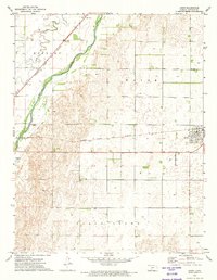
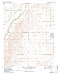
The Arkansas River corridor defines this portion of Edwards County, where the agricultural landscape meets the vital transportation artery of the Atchison Topeka and Santa Fe railroad. The settlement of Lewis serves as a primary hub for the region, complete with a central Park and proximity to the Fox Landing Strip, reflecting the integration of traditional rail and emerging small-scale aviation. To the northwest, the small community of Nettleton sits along the rail line near the winding path of Coon Creek. The map documents a terrain shaped by land use, showing several Gravel Pits and a substantial Feed Lot near the southern boundary, which illustrate the industrial and ranching practices prevalent in this section of central Kansas during the early 1970s.
Find a feature on this map
14 named features on this map. Tap any name to fly to it.
Don’t see what you’re looking for? This feature index may not catch every label — zoom into the map to look around manually.
Map Details
Editions of this 1972 Lewis Map
2 editions found
Other maps of this area

1889 · Larned
USGS Topo · 1:125,000

1889 · Kinsley
USGS Topo · 1:125,000

1891 · Larned
USGS Topo · 1:125,000

1892 · Kinsley
USGS Topo · 1:125,000

1894 · Kinsley
USGS Topo · 1:125,000

1955 · Great Bend
USGS Topo · 1:250,000

1955 · Pratt
USGS Topo · 1:250,000

1957 · Great Bend
USGS Topo · 1:250,000

1958 · Great Bend
USGS Topo · 1:250,000

1959 · Pratt
USGS Topo · 1:250,000