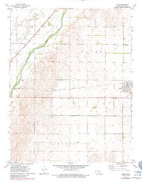
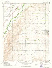
1972 Map of Lewis
USGS Topo · Published 1984About this map
The Arkansas River corridor in Edwards County defines this landscape, where the riparian valley transitions into the surrounding townships of Kinsley, Wayne, and North Brown. Central to the region's transport is the Atchison Topeka and Santa Fe railroad, which parallels the river and connects the small settlement of Nettleton to the community of Lewis. This area reflects the agricultural and infrastructural development of the early 1970s, featuring local landmarks such as a large Feed Lot and the Fox Landing Strip. The presence of numerous irrigation wells across the plains illustrates the intensive water management necessary for the region's farming economy. In the town of Lewis, a clearly defined street grid includes a local Park, providing a detailed look at the layout of this Kansas prairie town as it appeared during this era.
Find a feature on this map
13 named features on this map. Tap any name to fly to it.
Don’t see what you’re looking for? This feature index may not catch every label — zoom into the map to look around manually.
Map Details
Editions of this 1972 Lewis Map
2 editions found
Other maps of this area

1889 · Larned
USGS Topo · 1:125,000

1889 · Kinsley
USGS Topo · 1:125,000

1891 · Larned
USGS Topo · 1:125,000

1892 · Kinsley
USGS Topo · 1:125,000

1894 · Kinsley
USGS Topo · 1:125,000

1955 · Great Bend
USGS Topo · 1:250,000

1955 · Pratt
USGS Topo · 1:250,000

1957 · Great Bend
USGS Topo · 1:250,000

1958 · Great Bend
USGS Topo · 1:250,000

1959 · Pratt
USGS Topo · 1:250,000