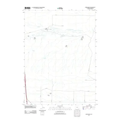
2012 Map of Lewis Ranch
USGS Topo · Published 2012About this map
The Lewis Ranch area of Laramie County is defined by an extensive network of irrigation and water management infrastructure designed for high-plains agriculture. This 2012 survey shows the winding course of Horse Cr and its associated man-made diversions, including Carey Horse Creek Ditch Number 9 and several others numbered through ten. This sophisticated water system supports the ranching landscape, feeding a series of catchment areas such as Carey Reservoir Number 1 and Number 6 Reservoir. The terrain is further etched by a series of named drainages including Lewis Draw, Nimmo Draw, and Shelton Draw. Transportation in this part of Wyoming is primarily facilitated by a grid of county roads like Co RD-232 and Indian Hill Rd, while the modern corridor of the I-25 Service Rd E skirts the western edge of the quadrangle.
Find a feature on this map
31 named features on this map. Tap any name to fly to it.
Don’t see what you’re looking for? This feature index may not catch every label — zoom into the map to look around manually.
Map Details
Editions of this 2012 Lewis Ranch Map
This is the sole edition of this map. No revisions or reprints were ever made.
Other maps of this area

1911 · Cheyenne
USGS Topo · 1:125,000

1914 · Cheyenne
USGS Topo · 1:125,000

1954 · Cheyenne
USGS Topo · 1:250,000

1958 · Cheyenne
USGS Topo · 1:250,000

1962 · P O Ranch
USGS Topo · 1:24,000

1962 · Moffett Ranch
USGS Topo · 1:24,000
1962 · Farthing Ranch
USGS Topo · 1:24,000

1962 · Lewis Ranch
USGS Topo · 1:24,000

1962 · Bristol Ridge
USGS Topo · 1:24,000
1962 · Nimmo Ranch
USGS Topo · 1:24,000