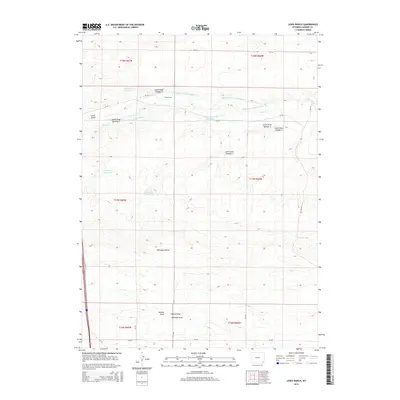
2015 Map of Lewis Ranch
USGS Topo · Published 2015About this map
Lewis Ranch serves as the focal point of this Laramie County landscape, where an intricate network of irrigation ditches and reservoirs defines the arid terrain. The mapping of Carey Horse Cr Ditch Number 9, Carey Horse Cr Ditch Number 10, and others highlights the critical importance of water management for cattle ranching and agriculture in Wyoming. These engineered waterways redirect Horse Creek to fill multiple storage basins including Number 1 Reservoir, Number 5 Reservoir, and Carey Reservoir Number 1. Significant geographical depressions and drainages such as Lewis Draw, Chivington Draw, and Nimmo Draw break the high plains, providing a detailed look at the local topography as it functioned in the early 21st century. This survey preserves the exact placement of rural county roads like CR-232 and CR-124, which connect these remote ranching outposts.
Find a feature on this map
35 named features on this map. Tap any name to fly to it.
Don’t see what you’re looking for? This feature index may not catch every label — zoom into the map to look around manually.
Map Details
Editions of this 2015 Lewis Ranch Map
This is the sole edition of this map. No revisions or reprints were ever made.
Other maps of this area

1911 · Cheyenne
USGS Topo · 1:125,000

1914 · Cheyenne
USGS Topo · 1:125,000

1954 · Cheyenne
USGS Topo · 1:250,000

1958 · Cheyenne
USGS Topo · 1:250,000

1962 · P O Ranch
USGS Topo · 1:24,000

1962 · Moffett Ranch
USGS Topo · 1:24,000
1962 · Farthing Ranch
USGS Topo · 1:24,000

1962 · Lewis Ranch
USGS Topo · 1:24,000

1962 · Bristol Ridge
USGS Topo · 1:24,000
1962 · Nimmo Ranch
USGS Topo · 1:24,000