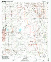
1996 Map of Lewis Springs
USGS Topo · Published 2002About this map
Sierra Vista expands toward the high desert landscape of Cochise County in this late 20th-century survey. The western edge of the map is dominated by the Fort Huachuca Military Reservation, while the eastern portion highlights the ecological significance of the San Pedro Riparian National Conservation Area. Along the San Pedro River, the transition from historical land grants like the San Rafael del Valle Grant to modern conservation efforts is evident. Evidence of the region's transport history appears via the Old Railroad Grade passing near Lewis Springs. Local land use is reflected in family landmarks such as the Donnet-Fry Ranch and Bakarich-McCool Ranch, while features like Brunckow Hill and the San Pedro House provide specific points of interest for those tracing the development of the valley's cattle and mining heritage.
Find a feature on this map
23 named features on this map. Tap any name to fly to it.
Don’t see what you’re looking for? This feature index may not catch every label — zoom into the map to look around manually.
Map Details
Editions of this 1996 Lewis Springs Map
This is the sole edition of this map. No revisions or reprints were ever made.
Other maps of this area

1914 · Hereford
USGS Topo · 1:125,000

1915 · Benson
USGS Topo · 1:125,000

1922 · Sunnyside
USGS Topo · 1:62,500

1932 · Stark
USGS Topo · 1:62,500

1932 · Fairbank
USGS Topo · 1:62,500

1938 · Huachuca
USGS Topo · 1:62,500

1938 · Sunnyside
USGS Topo · 1:62,500

1943 · Benson
USGS Topo · 1:125,000

1948 · Fort Huachuca NE
USGS Topo · 1:24,000

1948 · Miller Peak
USGS Topo · 1:24,000