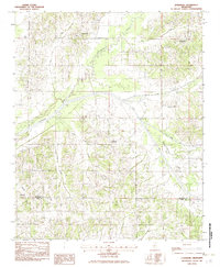
1982 Map of Lewisburg
USGS Topo · Published 1983About this map
Lewisburg and Cockrum anchor this 1980s landscape in the hills of northern Mississippi. The region is defined by the winding course of the Coldwater River, which moves through a network of smaller drainages including Short Creek and Dry Creek. The settlement pattern reflects the agricultural and rural character of the area, with small communities like Ingrams Mill and Stonewall situated near watercourses and crossroads. Along the southern edge of the sheet, the De Soto Co / Tate Co boundary line marks the transition between counties near the village of Alphaba. A complex web of local creeks, such as Little Jordan Creek and Pigeon Roost Creek, illustrates the natural drainage patterns that have historically influenced road placement and property lines across this part of the state.
Find a feature on this map
15 named features on this map. Tap any name to fly to it.
Don’t see what you’re looking for? This feature index may not catch every label — zoom into the map to look around manually.
Map Details
Editions of this 1982 Lewisburg Map
This is the sole edition of this map. No revisions or reprints were ever made.
Other maps of this area

1944 · Senatobia
USGS Topo · 1:62,500

1944 · Hernando
USGS Topo · 1:62,500

1944 · Tyro
USGS Topo · 1:62,500

1948 · Byhalia
USGS Topo · 1:62,500

1956 · Tupelo
USGS Topo · 1:250,000

1958 · Tupelo
USGS Topo · 1:250,000
1971 · Byhalia
USGS Topo · 1:24,000

1971 · Wyatte
USGS Topo · 1:24,000
1971 · Byhalia NW
USGS Topo · 1:24,000
1975 · Senatobia NW
USGS Topo · 1:24,000