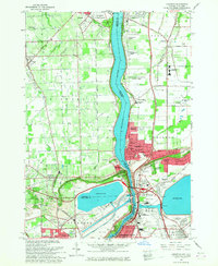
1965 Map of Lewiston
USGS Topo · Published 1968About this map
The Niagara River serves as the international boundary between Ontario and New York in this mid-1960s survey, a landscape defined by the sharp rise of the Niagara Escarpment. On the American side, the village of Lewiston and its neighboring Riverside Manors sit just north of where the New York Central rail line once traversed the terrain. The area is a significant hub for religious and educational institutions, featuring the Stella Niagara Seminary, Niagara University, and the Our Lady of Fatima Shrine. Local infrastructure includes a large Reservoir and the Dolansky Landing Strip, while the Canadian shore is home to Queenston Heights and the sprawling Brockton Park. Genealogists will find numerous burial sites documented, including St Johns Cem, Beth Israel Cem, and Niagara Falls Memorial Park.
Find a feature on this map
72 named features on this map. Tap any name to fly to it.
Don’t see what you’re looking for? This feature index may not catch every label — zoom into the map to look around manually.
Map Details
Editions of this 1965 Lewiston Map
This is the sole edition of this map. No revisions or reprints were ever made.
Other maps of this area

1894 · Niagara Falls
USGS Topo · 1:62,500

1894 · Wilson
USGS Topo · 1:62,500

1896 · Niagara Falls
USGS Topo · 1:62,500

1897 · Tonawanda
USGS Topo · 1:62,500

1899 · Niagara
USGS Topo · 1:125,000

1900 · Wilson
USGS Topo · 1:62,500

1900 · Tonawanda
USGS Topo · 1:62,500

1900 · Niagara Falls
USGS Topo · 1:62,500

1901 · Niagara Falls
USGS Topo · 1:62,500

1901 · Tonawanda
USGS Topo · 1:62,500