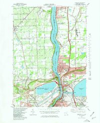
1980 Map of Lewiston
USGS Topo · Published 1981About this map
The Niagara River serves as the international boundary and central axis of this 1980 survey, illustrating the complex infrastructure of the Niagara Escarpment. The landscape is dominated by massive engineering projects, including the Reservoir and the Robert Moses Powerplant, which reshaped the terrain south of Lewiston Heights. To the north, the riverbanks transitions into established residential and institutional zones, such as the Stella Niagara complex and the sprawling Lewiston-Porter Central Schools campus.
Find a feature on this map
73 named features on this map. Tap any name to fly to it.
Don’t see what you’re looking for? This feature index may not catch every label — zoom into the map to look around manually.
Map Details
Editions of this 1980 Lewiston Map
This is the sole edition of this map. No revisions or reprints were ever made.
Other maps of this area

1894 · Niagara Falls
USGS Topo · 1:62,500

1894 · Wilson
USGS Topo · 1:62,500

1896 · Niagara Falls
USGS Topo · 1:62,500

1897 · Tonawanda
USGS Topo · 1:62,500

1899 · Niagara
USGS Topo · 1:125,000

1900 · Wilson
USGS Topo · 1:62,500

1900 · Tonawanda
USGS Topo · 1:62,500

1900 · Niagara Falls
USGS Topo · 1:62,500

1901 · Niagara Falls
USGS Topo · 1:62,500

1901 · Tonawanda
USGS Topo · 1:62,500