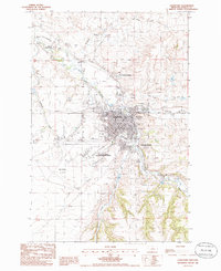
1985 Map of Lewistown
USGS Topo · Published 1986About this map
Lewistown serves as the focal point of this mid-1980s central Montana survey, situated where the waters of Big Spring Creek meet several smaller tributaries. The map documents a community defined by its transportation and resource infrastructure, featuring the Roy-Winifred Junction and Lewistown Junction rail points alongside the Municipal Airport and the smaller Gillett Landing Strip. The presence of numerous Gravel Pits and a Clay Pit indicates the active extraction industries supporting the local economy during this era.
Find a feature on this map
30 named features on this map. Tap any name to fly to it.
Don’t see what you’re looking for? This feature index may not catch every label — zoom into the map to look around manually.
Map Details
Editions of this 1985 Lewistown Map
This is the sole edition of this map. No revisions or reprints were ever made.
Other maps of this area

1889 · Big Snowy Mountain
USGS Topo · 1:250,000

1893 · Big Snowy Mountain
USGS Topo · 1:250,000

1941 · Lewistown
USGS Topo · 1:62,500

1944 · Lewistown
USGS Topo · 1:62,500

1954 · Roundup
USGS Topo · 1:250,000

1954 · Lewistown
USGS Topo · 1:250,000

1958 · Roundup
USGS Topo · 1:250,000

1959 · Lewistown
USGS Topo · 1:250,000

1970 · Glengarry
USGS Topo · 1:24,000

1970 · Spring Creek Junction
USGS Topo · 1:24,000