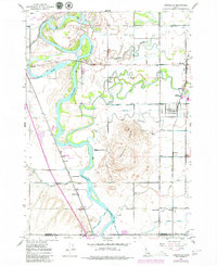
1948 Map of Lewisville
USGS Topo · Published 1979About this map
The Snake River dominates this landscape of the upper Snake River Plain, creating a complex network of braids and secondary channels such as Roberts Slough and the Dry Bed. This mid-century environment is defined by an intricate irrigation system essential for local agriculture, featuring the Missionary Canal, Long Island Canal, and Great Western Canal. The Union Pacific railroad tracks run parallel to the river corridor, supporting small agricultural hubs like Roberts, Bassett, and Lewisville. The geography transitions from the riparian wetlands of the Market Lake Wildlife Management Area to the prominent Lewisville Knolls. Cultural landmarks such as Midway High Sch and the Lewisville Cemetery reflect the established community centers of Jefferson and Bonneville counties during this era of post-war development.
Find a feature on this map
40 named features on this map. Tap any name to fly to it.
Don’t see what you’re looking for? This feature index may not catch every label — zoom into the map to look around manually.
Map Details
Editions of this 1948 Lewisville Map
3 editions found
Other maps of this area

1948 · Rigby
USGS Topo · 1:24,000

1948 · Lewisville
USGS Topo · 1:24,000

1948 · Idaho Falls North
USGS Topo · 1:24,000

1948 · Ucon
USGS Topo · 1:24,000

1949 · Ucon
USGS Topo · 1:24,000

1949 · Idaho Falls North
USGS Topo · 1:24,000

1949 · Rigby
USGS Topo · 1:24,000

1949 · Lewisville
USGS Topo · 1:24,000

1949 · Roberts
USGS Topo · 1:62,500

1949 · Roberts
USGS Topo · 1:24,000