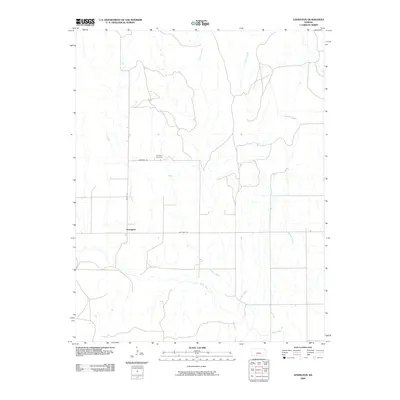
2009 Map of Lexington
USGS Topo · Published 2009About this map
Lexington serves as the focal point of this rural Clark County landscape, situated at the intersection of Old K St and Old Hwy 34. The settlement's history is anchored by the Lexington Cemetery located to the north along Cemetery Rd. This portion of the High Plains is defined by a network of seasonal watercourses, including Bluff Creek and Cavalry Creek, which carve subtle drainage patterns across the prairie. The road names suggest a shift in transportation infrastructure, as former state routes were redesignated or bypassed, leaving behind a quiet grid of local roads and family-named landmarks like Buzzard Creek and Lone Tree Creek. Genealogists and local historians can trace the precise layout of these early 21st-century property access points and the enduring presence of the community's burial grounds.
Find a feature on this map
10 named features on this map. Tap any name to fly to it.
Don’t see what you’re looking for? This feature index may not catch every label — zoom into the map to look around manually.
Map Details
Editions of this 2009 Lexington Map
This is the sole edition of this map. No revisions or reprints were ever made.
Other maps of this area

1892 · Coldwater
USGS Topo · 1:125,000

1894 · Sitka
USGS Topo · 1:62,500

1896 · Ashland
USGS Topo · 1:125,000

1955 · Pratt
USGS Topo · 1:250,000

1959 · Pratt
USGS Topo · 1:250,000

1979 · Sitka
USGS Topo · 1:24,000

1979 · Sugarloaf
USGS Topo · 1:24,000

1979 · Turkey Creek
USGS Topo · 1:24,000

1979 · East Kiowa Creek South
USGS Topo · 1:24,000
1979 · East Kiowa Creek North
USGS Topo · 1:24,000