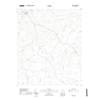
2020 Map of Lexington
USGS Topo · Published 2020About this map
The Oglethorpe County Courthouse stands at the heart of Lexington, anchoring this rural Georgia landscape where established family lineages are marked by numerous small burial grounds. Small settlements like Hogan punctuate a terrain defined by a dense network of watercourses, including Troublesome Cr, Brooks Cr, and Buffalo Cr. The map reveals a distribution of private and community history through several family-named cemeteries, such as the Smith-Freeman Cem, Wynne Cem, and Milner Cem. These sites, often situated near historic road junctions like Sims Cross Rd, provide essential reference points for genealogists tracking local ancestry. The topography rises toward Big Mtn in the east, while the road system, featuring routes like Washington Rd and Crawfordville Rd, reflects the longstanding transportation patterns of Oglethorpe County. This modern survey maintains the record of these traditional landmarks amidst the evolving agricultural and wooded landscape of the Piedmont.
Find a feature on this map
58 named features on this map. Tap any name to fly to it.
Don’t see what you’re looking for? This feature index may not catch every label — zoom into the map to look around manually.
Map Details
Editions of this 2020 Lexington Map
This is the sole edition of this map. No revisions or reprints were ever made.
Other maps of this area

1906 · Crawfordville
USGS Topo · 1:125,000

1953 · Athens
USGS Topo · 1:250,000

1958 · Athens
USGS Topo · 1:250,000

1959 · Athens
USGS Topo · 1:250,000

1963 · Athens
USGS Topo · 1:250,000

1965 · Woodville
USGS Topo · 1:24,000

1966 · Philomath
USGS Topo · 1:24,000
1971 · Sandy Cross
USGS Topo · 1:24,000
1971 · Crawford
USGS Topo · 1:24,000

1971 · Maxeys
USGS Topo · 1:24,000