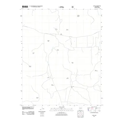
2011 Map of Leyba
USGS Topo · Published 2011About this map
Leyba Post Office and the seasonal dwellings of Shelly Hayes Camp anchor this high-plateau landscape in San Miguel County. The terrain is defined by a series of steep escarpments and canyon-carved flats, including Mesa de Aguilar and Mesa Portrero. These landforms suggest a reliance on ranching and seasonal grazing, supported by isolated water sources like the Shelly Windmill. The drainage of Cañada de Pueblo cuts through the center of the quadrangle, creating a natural corridor between the various rincones, such as Rincon Bonito and Rincon del Leon. This 2011 survey captures the rural infrastructure of Northern New Mexico, where unpaved county roads like County Rd-B31A navigate the transitions between open mesas and protected valley floors like Valle Chimal.
Find a feature on this map
21 named features on this map. Tap any name to fly to it.
Don’t see what you’re looking for? This feature index may not catch every label — zoom into the map to look around manually.
Map Details
Editions of this 2011 Leyba Map
This is the sole edition of this map. No revisions or reprints were ever made.
Other maps of this area

1890 · Bernal
USGS Topo · 1:125,000

1891 · Bernal
USGS Topo · 1:125,000

1894 · Bernal
USGS Topo · 1:125,000

1894 · Lamy
USGS Topo · 1:125,000

1954 · Santa Fe
USGS Topo · 1:250,000

1958 · Santa Fe
USGS Topo · 1:250,000

1960 · Villanueva
USGS Topo · 1:62,500

1963 · Jacinto Mesa
USGS Topo · 1:24,000

1963 · Aurora
USGS Topo · 1:24,000
1966 · El Cabo
USGS Topo · 1:24,000