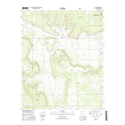
2017 Map of Leyba
USGS Topo · Published 2017About this map
The high mesa country of San Miguel County is defined here by a series of dramatic landforms and the small settlement of Leyba. Situated in a landscape carved by deep canyons and flat-topped highlands, the area includes a portion of the Santa Fe National Forest in the northeast corner. This 2017 survey details a high-elevation environment where water management is critical, evidenced by scattered livestock tanks such as Leyba Tank, North Tank, and Benada Tank. The terrain is characterized by expansive features like Mesa de Aguilar and Mesa de la Mula, alongside sheltered areas like Valle Chimal and Rincon del Leon. A network of county roads, including Co RD b31a and Co RD B-31-B, provides the primary access through the drainage systems of Cañada de Pueblo and Arroyo de los Diegos. This map serves as a modern record of traditional land use and geography in north-central New Mexico.
Find a feature on this map
33 named features on this map. Tap any name to fly to it.
Don’t see what you’re looking for? This feature index may not catch every label — zoom into the map to look around manually.
Map Details
Editions of this 2017 Leyba Map
This is the sole edition of this map. No revisions or reprints were ever made.
Other maps of this area

1890 · Bernal
USGS Topo · 1:125,000

1891 · Bernal
USGS Topo · 1:125,000

1894 · Bernal
USGS Topo · 1:125,000

1894 · Lamy
USGS Topo · 1:125,000

1954 · Santa Fe
USGS Topo · 1:250,000

1958 · Santa Fe
USGS Topo · 1:250,000

1960 · Villanueva
USGS Topo · 1:62,500

1963 · Jacinto Mesa
USGS Topo · 1:24,000

1963 · Aurora
USGS Topo · 1:24,000
1966 · El Cabo
USGS Topo · 1:24,000