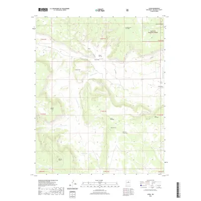
2020 Map of Leyba
USGS Topo · Published 2020About this map
The small community of Leyba sits along the northern edge of this high-altitude landscape in San Miguel County, where the high plains meet the edges of the Santa Fe National Forest. This high country is defined by a series of prominent mesas and deep canyons, including Mesa de Aguilar, Mesa Portrero, and Mesa de la Mula. The drainage patterns are clearly visible through names like Cañada de Pueblo and Arroyo de los Diegos, which carve through the terrain toward lower basins. Local water management is evident in the presence of several established reservoirs, such as Benada Tank and Lower Agua Tank. The map reveals a network of county roads like Co RD b31a and Co RD b31b that connect these remote ranching areas, highlighting a landscape where natural topography dictates the movement of people and livestock through features like Valle Chimal and Rincon del Leon.
Find a feature on this map
32 named features on this map. Tap any name to fly to it.
Don’t see what you’re looking for? This feature index may not catch every label — zoom into the map to look around manually.
Map Details
Editions of this 2020 Leyba Map
This is the sole edition of this map. No revisions or reprints were ever made.
Other maps of this area

1890 · Bernal
USGS Topo · 1:125,000

1891 · Bernal
USGS Topo · 1:125,000

1894 · Bernal
USGS Topo · 1:125,000

1894 · Lamy
USGS Topo · 1:125,000

1954 · Santa Fe
USGS Topo · 1:250,000

1958 · Santa Fe
USGS Topo · 1:250,000

1960 · Villanueva
USGS Topo · 1:62,500

1963 · Jacinto Mesa
USGS Topo · 1:24,000

1963 · Aurora
USGS Topo · 1:24,000
1966 · El Cabo
USGS Topo · 1:24,000