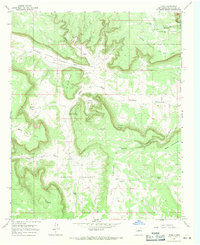
1966 Map of Leyba
USGS Topo · Published 1971About this map
The settlement of Leyba serves as a small focal point in this 1960s survey of San Miguel County, tucked within the branching drainages of Cañon Blanco. The landscape is defined by its mesa-and-canyon topography, where names like La Mesa Pobre and Mesa Portrero indicate a long history of grazing and ranching. Evidence of early habitation is visible at the El Cablito Indian Ruins and further south at Old Indian Ruins near Cañada del Pueblo, suggesting the area's deep archaeological significance. Local religious and community life centers on the San Francisco Cem Ch, while the remote character of the high country is reinforced by features like the Shelly Hayes Camp and Shelly Windmill. The northeastern corner transitions into the protected timberlands of the Santa Fe National Forest, while various water tanks such as Leyba Tank and Rock Tank mark the critical infrastructure needed to sustain life in this arid terrain.
Find a feature on this map
32 named features on this map. Tap any name to fly to it.
Don’t see what you’re looking for? This feature index may not catch every label — zoom into the map to look around manually.
Map Details
Editions of this 1966 Leyba Map
This is the sole edition of this map. No revisions or reprints were ever made.
Other maps of this area

1890 · Bernal
USGS Topo · 1:125,000

1891 · Bernal
USGS Topo · 1:125,000

1894 · Bernal
USGS Topo · 1:125,000

1894 · Lamy
USGS Topo · 1:125,000

1954 · Santa Fe
USGS Topo · 1:250,000

1958 · Santa Fe
USGS Topo · 1:250,000

1960 · Villanueva
USGS Topo · 1:62,500

1963 · Jacinto Mesa
USGS Topo · 1:24,000

1963 · Aurora
USGS Topo · 1:24,000
1966 · El Cabo
USGS Topo · 1:24,000