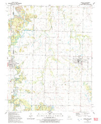
1991 Map of Liberal
USGS Topo · Published 1991About this map
Liberal sits at the eastern edge of this Missouri-Kansas borderlands survey, serving as a local hub with its High Sch and Middle Sch. The landscape is defined by the transition from agriculture to protected prairie, notably anchored by the expansive Prairie State Park and the Lester R Davis State Forest to the south. Small settlements like Mulberry and Burgess dot the western side near the state line, while a network of cemeteries including Rosebank Cem and Leroy Cem provide valuable markers for genealogical research. Waterways like East Drywood Creek and Nicolson Creek wind through the terrain, which is punctuated by topographical features such as Haake Mound. The presence of a Radio Tower and WT infrastructure alongside old rail beds highlights the intersection of rural life and modernization in the early 1990s.
Find a feature on this map
29 named features on this map. Tap any name to fly to it.
Don’t see what you’re looking for? This feature index may not catch every label — zoom into the map to look around manually.
Map Details
Editions of this 1991 Liberal Map
This is the sole edition of this map. No revisions or reprints were ever made.
Other maps of this area

1884 · Fort Scott
USGS Topo · 1:125,000

1886 · Nevada
USGS Topo · 1:125,000

1886 · Joplin
USGS Topo · 1:125,000

1886 · Fort Scott
USGS Topo · 1:125,000

1886 · Carthage
USGS Topo · 1:125,000

1893 · Fort Scott
USGS Topo · 1:125,000

1894 · Nevada
USGS Topo · 1:125,000

1894 · Joplin
USGS Topo · 1:125,000

1894 · Carthage
USGS Topo · 1:125,000

1945 · Pittsburg
USGS Topo · 1:62,500