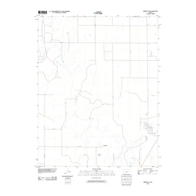
2010 Map of Liberal NE
USGS Topo · Published 2010About this map
The Cimarron River winds through this section of Seward County, creating a riparian corridor that contrasts sharply with the surrounding agricultural grid of Southwest Kansas. Near the center of the sheet lies the settlement of Arkalon, a location once established as a railroad shipping point along the river. The small Arkalon Cemetery remains as a tangible connection to the early families who settled this prairie landscape. The area is defined by a systematic road network, including thoroughfares such as Webb Rd and 7 Mile Rd, which partition the land into large, productive sections typical of the High Plains. While the town of Arkalon has largely faded from its once-busy status as a river crossing and cattle hub, the map preserves the exact layout of its former footprint and its enduring landmarks.
Find a feature on this map
12 named features on this map. Tap any name to fly to it.
Don’t see what you’re looking for? This feature index may not catch every label — zoom into the map to look around manually.
Map Details
Editions of this 2010 Liberal NE Map
This is the sole edition of this map. No revisions or reprints were ever made.
Other maps of this area

1955 · Dodge City
USGS Topo · 1:250,000

1958 · Dodge City
USGS Topo · 1:250,000

1959 · Dodge City
USGS Topo · 1:250,000

1968 · Plains SW
USGS Topo · 1:24,000

1968 · Sublette SW
USGS Topo · 1:24,000

1968 · Liberal NE
USGS Topo · 1:24,000

1968 · Sublette SE
USGS Topo · 1:24,000

1968 · Liberal NW
USGS Topo · 1:24,000

1971 · Liberal
USGS Topo · 1:24,000
1971 · Kismet
USGS Topo · 1:24,000