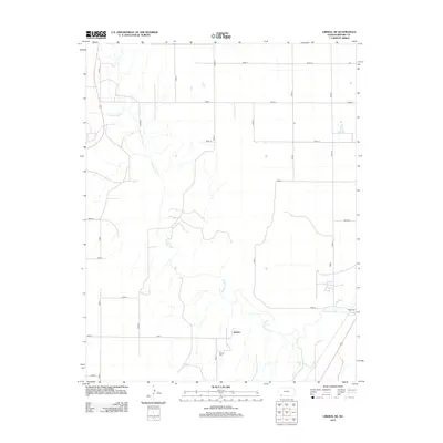
2012 Map of Liberal NE
USGS Topo · Published 2012About this map
The Cimarron River carves a winding path through the southwest corner of Seward County, anchoring a landscape defined by its grid-based infrastructure. The settlement of Arkalon stands near the riverbanks, serving as a primary point of interest alongside the Arkalon Cem. This area reflects the organized development of the High Plains, where a rigorous network of numbered and lettered thoroughfares like Road 14 and Road L partition the land into precise sections. The tiny community of Shamrock appears on the eastern edge of the river valley, illustrating the sparse but deliberate distribution of homesteads and small hubs in this part of Kansas. The contrast between the meandering natural riverbed and the rigid geometry of the road system highlights the intersection of the natural environment and human settlement in the early 21st century.
Find a feature on this map
20 named features on this map. Tap any name to fly to it.
Don’t see what you’re looking for? This feature index may not catch every label — zoom into the map to look around manually.
Map Details
Editions of this 2012 Liberal NE Map
This is the sole edition of this map. No revisions or reprints were ever made.
Other maps of this area

1955 · Dodge City
USGS Topo · 1:250,000

1958 · Dodge City
USGS Topo · 1:250,000

1959 · Dodge City
USGS Topo · 1:250,000

1968 · Plains SW
USGS Topo · 1:24,000

1968 · Sublette SW
USGS Topo · 1:24,000

1968 · Liberal NE
USGS Topo · 1:24,000

1968 · Sublette SE
USGS Topo · 1:24,000

1968 · Liberal NW
USGS Topo · 1:24,000

1971 · Liberal
USGS Topo · 1:24,000
1971 · Kismet
USGS Topo · 1:24,000