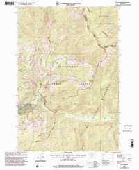
1998 Map of Lick Creek
USGS Topo · Published 2002About this map
The Sapphire Mountains define the northeastern corner of this high-elevation Montana landscape, where the Bitterroot National Forest meets the protected reaches of the Anaconda-Pintler Wilderness. This map captures a remote area of the Sapphire and Anaconda ranges near the border of Granite and Ravalli counties. The drainage network is anchored by the East Fork Bitterroot River, which receives numerous tributaries including Bush Creek, Moose Creek, and Martin Creek. Historical fire watch infrastructure is evident at Tepee Point Lookout and Mc Cart Lookout, while the local topography features notable landmarks such as Kent Peak and the curiously labeled Hole in the Wall. Recreational and utility access is shown via the Sign Creek Trail and East Fork Trail, providing a clear view of the mountain passes and saddles used to navigate this terrain in the late 1990s.
Find a feature on this map
38 named features on this map. Tap any name to fly to it.
Don’t see what you’re looking for? This feature index may not catch every label — zoom into the map to look around manually.
Map Details
Editions of this 1998 Lick Creek Map
This is the sole edition of this map. No revisions or reprints were ever made.
Other maps of this area

1909 · Sapphire
USGS Topo · 1:125,000

1947 · Butte
USGS Topo · 1:250,000

1955 · Dillon
USGS Topo · 1:250,000

1957 · Dillon
USGS Topo · 1:250,000

1958 · Butte
USGS Topo · 1:250,000

1958 · Dillon
USGS Topo · 1:250,000

1960 · Butte
USGS Topo · 1:250,000

1962 · Butte
USGS Topo · 1:250,000

1962 · Dillon
USGS Topo · 1:250,000

1965 · Dillon
USGS Topo · 1:250,000