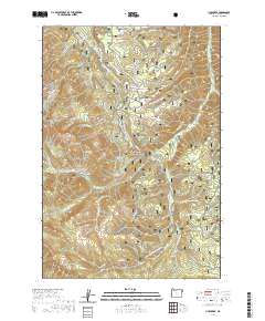
2020 Map of Lick Creek
USGS Topo · Published 2020About this map
The Wallowa National Forest dominates this mountain landscape, defined by a network of drainage systems and high-altitude ridges. The rugged interior is carved by Big Sheep Creek and its many tributaries, including S Fork Big Sheep Creek and N Fork Big Sheep Creek, alongside the namesake Lick Creek. Human infrastructure is sparse and seasonal, centered around recreational routes and hydraulic management such as the Wallowa Valley Improvement Canal. Historically significant paths like the Tenderfoot Wagon Road cross the terrain, while the Imnaha Divide and Wing Ridge provide distinct geographical boundaries. The presence of numerous specialized trails, such as the Nebo Snowmobile and Lick Creek OHV routes, underscores the modern utility of this wilderness for remote exploration and resource management within Wallowa County.
Find a feature on this map
47 named features on this map. Tap any name to fly to it.
Don’t see what you’re looking for? This feature index may not catch every label — zoom into the map to look around manually.
Map Details
Editions of this 2020 Lick Creek Map
This is the sole edition of this map. No revisions or reprints were ever made.
Other maps of this area

1954 · Cornucopia
USGS Topo · 1:62,500

1954 · Harl Butte
USGS Topo · 1:62,500

1955 · Grangeville
USGS Topo · 1:250,000

1957 · Joseph
USGS Topo · 1:62,500

1957 · Homestead
USGS Topo · 1:62,500

1959 · Grangeville
USGS Topo · 1:250,000

1986 · Enterprise
USGS Topo · 1:100,000

1987 · Riggins
USGS Topo · 1:100,000
1990 · Deadman Point
USGS Topo · 1:24,000
1990 · Gumboot Butte
USGS Topo · 1:24,000