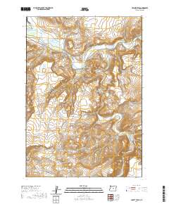
2020 Map of Liggett Table
USGS Topo · Published 2020About this map
Crooked River dominates the northern landscape of this Crook County quadrangle, where the water cuts through high desert terrain. The confluence of the S Fork Crooked River and main stem highlights a critical drainage point in the region's geography. To the southwest, the prominent elevation of Hawk Rim defines the horizon, providing a natural overlook above the winding path of Kelly Cr. This 2020 map details the complex topography of a sparsely populated area characterized by significant elevation changes and seasonal watercourses like Beaver Cr. The arrangement of these water features suggests a landscape shaped by the erosive power of the river system over time, with the South Fork joining the primary channel amidst a series of deep draws and high tables.
Find a feature on this map
9 named features on this map. Tap any name to fly to it.
Don’t see what you’re looking for? This feature index may not catch every label — zoom into the map to look around manually.
Map Details
Editions of this 2020 Liggett Table Map
This is the sole edition of this map. No revisions or reprints were ever made.
Other maps of this area

1932 · Dayville
USGS Topo · 1:125,000

1936 · Dayville
USGS Topo · 1:125,000

1955 · Crescent
USGS Topo · 1:250,000

1955 · Bend
USGS Topo · 1:250,000

1955 · Burns
USGS Topo · 1:250,000

1955 · Canyon City
USGS Topo · 1:250,000

1957 · Crescent
USGS Topo · 1:250,000

1957 · Bend
USGS Topo · 1:250,000

1958 · Crescent
USGS Topo · 1:250,000

1958 · Burns
USGS Topo · 1:250,000