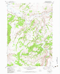
1982 Map of Liggett Table
USGS Topo · Published 1983About this map
The high plateau landscape of Liggett Table and Upper Table dominates this central Oregon survey, defined by deep incisions from the Crooked River and its various forks. This 1980s-era map captures a remote section of Crook County where cattle ranching and land management intersect. Evidence of human infrastructure is centered around the Paulina Guard Station and the Twin Buttes Ranch, while a small Landing Strip on the tableland suggests the reliance on aviation in these isolated regions. Notable geological and water features are scattered across the mesas and canyons, including the seasonal Sage Lake, St Peters Cave tucked beneath War Club Rim, and numerous cattle tanks like Bacon Res. Small-scale resource extraction is also visible through several Borrow Pits and Quarries located along the Paulina Highway.
Find a feature on this map
49 named features on this map. Tap any name to fly to it.
Don’t see what you’re looking for? This feature index may not catch every label — zoom into the map to look around manually.
Map Details
Editions of this 1982 Liggett Table Map
This is the sole edition of this map. No revisions or reprints were ever made.
Other maps of this area

1932 · Dayville
USGS Topo · 1:125,000

1936 · Dayville
USGS Topo · 1:125,000

1955 · Crescent
USGS Topo · 1:250,000

1955 · Bend
USGS Topo · 1:250,000

1955 · Burns
USGS Topo · 1:250,000

1955 · Canyon City
USGS Topo · 1:250,000

1957 · Crescent
USGS Topo · 1:250,000

1957 · Bend
USGS Topo · 1:250,000

1958 · Crescent
USGS Topo · 1:250,000

1958 · Burns
USGS Topo · 1:250,000